Dharti Survey - Land Surveyors ☏ +91 98243 33470
Road Level Survey and Cross-Section Mapping for Infrastructure Projects in Gujarat
Dharti Survey provides accurate road level and cross-section surveys for roads, highways, and infrastructure projects in Gujarat.
Team Dharti survey
11/5/20251 min read
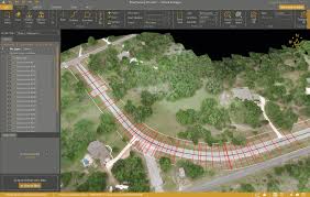

Every successful road or highway project starts with an accurate understanding of the terrain. A Road Level Survey, along with Cross-Section (C/S) Mapping, ensures that the road design matches real-world conditions — minimizing construction errors and costs.
🛣️ What Is a Road Level Survey?
It’s a survey that records the existing ground levels along the proposed road alignment. Engineers use this data to design the vertical profile and drainage slopes.
📉 What Is a Cross-Section Survey?
Cross-section surveys show the terrain profile at right angles to the road centerline, helping calculate cut and fill quantities and determine the road’s structural layers.
⚙️ Benefits of Accurate Road Level Surveys
Ensures smooth gradients for driving comfort
Helps plan stormwater drainage and culverts
Reduces material wastage during earthwork
Prevents uneven settlements post-construction
📍 Dharti Survey’s Infrastructure Expertise
With experience in road alignment, leveling, and C/S surveys across Gujarat, Dharti Survey supports contractors and engineers with Total Station & DGPS-based data collection for precise designs.
For roads that last and perform, rely on Dharti Survey — Gujarat’s reliable name in road level and cross-section surveying.
Services
We offer reliable land surveying services in Mahemdavad, District Kheda and Ahmedabad.
Contact
B-104, City Point Complex, Haldharvas Modaj Road, Mahemdavad, Kheda, Gujarat. 387110
© 2025. All rights reserved.
Bhathi Zala ☏ +91 98243 33470
Dinesh Zala ☏ +91 98243 33477
Rajesh Zala ☏ +91 98243 33478
Office
✉️ Our Email