Dharti Survey - Land Surveyors ☏ +91 98243 33470
DGPS Survey for Government and Infrastructure Projects in Gujarat
Discover how DGPS surveys by Dharti Survey ensure high accuracy in government and infrastructure projects across Gujarat.
Team Dharti Survey
11/5/20251 min read

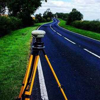
Large-scale infrastructure and government projects — from highways to irrigation canals — require the highest level of precision in mapping and measurement. That’s where DGPS (Differential Global Positioning System) surveys play a vital role.
🌐 What Is a DGPS Survey?
A DGPS survey uses satellite-based technology with a reference base station to provide highly accurate geographical coordinates. The accuracy can reach within 2–5 centimeters, making it ideal for professional engineering and government use.
🏗️ Where DGPS Surveys Are Used
Road and highway alignments
Canal and pipeline projects
Land acquisition and mapping
Forest and watershed management
City planning and GIS mapping
⚙️ Benefits of DGPS Survey
High precision for large-scale projects
Real-time error correction
Faster coverage of vast areas
Integration with GIS and CAD systems
📍 Dharti Survey’s Experience
At Dharti Survey, we have conducted multiple DGPS surveys across Ahmedabad, Kheda, and nearby districts, supporting contractors, government engineers, and developers with accurate coordinate-based reports.
When precision and compliance matter most, trust Dharti Survey — your reliable DGPS survey partner in Gujarat.
Services
We offer reliable land surveying services in Mahemdavad, District Kheda and Ahmedabad.
Contact
B-104, City Point Complex, Haldharvas Modaj Road, Mahemdavad, Kheda, Gujarat. 387110
© 2025. All rights reserved.
Bhathi Zala ☏ +91 98243 33470
Dinesh Zala ☏ +91 98243 33477
Rajesh Zala ☏ +91 98243 33478
Office
✉️ Our Email