Dharti Survey - Land Surveyors ☏ +91 98243 33470
Contour Survey: The Backbone of Effective Land Development in Ahmedabad
Learn how contour surveys by Dharti Survey help in land leveling, drainage design, and site development across Ahmedabad and Gujarat.
Team Dharti Survey
11/5/20251 min read

Before starting any major construction or infrastructure project in Ahmedabad, it’s essential to understand the natural shape and slope of the land. This is where a Contour Survey becomes critical.
🏗️ What Is a Contour Survey?
A contour survey maps the elevations and depressions of the ground surface, showing how the land rises and falls. It is essential for:
Designing drainage systems
Road and canal alignment
Building layout and site planning
🌾 Why Contour Surveys Matter
Prevents Flooding & Waterlogging – Proper contour data ensures efficient stormwater management.
Helps in Land Leveling – Ideal for agricultural, residential, and industrial site preparation.
Accurate Design Inputs – Engineers can plan earthwork and slopes correctly.
Saves Cost – Avoids unnecessary excavation or fill during construction.
🧭 Dharti Survey’s Expertise
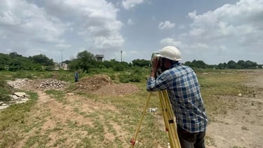
Using Total Station and DGPS, Dharti Survey delivers highly accurate contour maps for projects of all sizes.
Our experienced team has completed numerous contour surveys in Ahmedabad, Kheda, Anand, and Surendranagar — helping builders and developers make informed design decisions.
For precise contour and level surveys in Gujarat, trust Dharti Survey — where accuracy meets experience.
Services
We offer reliable land surveying services in Mahemdavad, District Kheda and Ahmedabad.
Contact
B-104, City Point Complex, Haldharvas Modaj Road, Mahemdavad, Kheda, Gujarat. 387110
© 2025. All rights reserved.
Bhathi Zala ☏ +91 98243 33470
Dinesh Zala ☏ +91 98243 33477
Rajesh Zala ☏ +91 98243 33478
Office
✉️ Our Email